









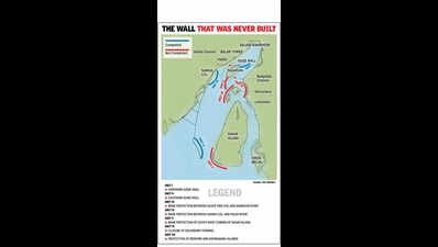
Kolkata: The engineers who drew up a river-training scheme for the lower Hooghly in 1981 — to keep the approach to Haldia port navigable for large cargo vessels — knew that part of their plan would intensify erosion along the shores of three islands downstream — two of them inhabited. So they included a protective wall for those islands as the final component of the scheme. That wall was never built. And two of those islands are now gone.The 1991 Census of India recorded 374 people living on Lohachara Island in the Hooghly estuary. Six years later, they had all left, their homes overtaken by water that would not stop rising. By 2006, Lohachara had disappeared. A second island in the same cluster, Bedford, was uninhabited. It too has gone. A third, Ghoramara — whose population ran into the thousands in successive censuses — has lost more than half its land area over the past few decades and continues to erode at up to 36 metres of shoreline a year at its most exposed sections.These islands became briefly famous as the world’s first inhabited islands claimed by rising seas. Documents obtained from Kolkata Port Trust under the Right to Information Act, however, tell a more specific story. A port development scheme formulated in 1981 had explicitly named a component: ‘Protection of Bedford and Ghoramara Islands’. In RTI replies, KoPT confirmed it was never built. Asked what caused the disappearance of Lohachara and Bedford, KoPT said: “Growth/decay of Islands is a natural process.“The wall in question was Unit VII of a seven-part engineering scheme for the lower Hooghly estuary. It was to be placed on the western face of Bedford and Ghoramara, designed to absorb the tidal energy that the rest of the scheme might redirect towards — and against — those islands. It was the scheme’s own acknowledgement, written into its design.To understand why, consider what the scheme was built to do. The Farakka Barrage, completed upriver in 1975, had reduced freshwater flow into the lower Hooghly, weakening its ability to flush silt seaward. The approach channel to Haldia Dock Complex was silting up. In 1981, the shipping ministry adopted the ‘Comprehensive Scheme for the Improvement of Draught in the Hooghly Estuary’ — a seven-part plan to concentrate the river’s tidal force into the Haldia-facing western channel, scouring it deeper for larger vessels.The problem was the geography below Haldia. The Hooghly there divides around a large river island called Nayachara, splitting tidal flow between the western Haldia channel and the eastern Rangafalla, which runs past Ghoramara, Bedford and Lohachara.In the early 1990s, Unit I — a 2,800-metre guide wall at Nayachara’s northern tip — was completed. It did what it was designed to do: Redirect tidal energy towards Haldia. After that, what happened downstream was recorded in a peer-reviewed research published in the Journal of the Indian Society of Remote Sensing: As Nayachara grew with accumulated sediment, Ghoramara simultaneously shrank. That divergence in the satellite record has continued for decades.Unit VII was the answer to that consequence — the protection the scheme’s own engineers had built into the design precisely because they knew Unit I would have this effect. Three of the seven planned components were built.The wall for Ghoramara, Lohachara and Bedford was not among them. Without it, and the three other unbuilt components, the islands had no protection against the force of the currents.Tuhin Ghosh, director of the School of Oceanographic Studies, Jadavpur University, and lead author of the IPCC Special Report on the Ocean and Cryosphere says: “The port’s river training plan prepared by Dutch consulting called for seven guide walls. Only one underwater guide wall — in the north of Nayachara, a bank protection near Haldi river outfall, and the one for the closure of the secondary channel were built. And that fundamentally changed the hydrodynamic condition of the river. The greater impact here is from the incomplete intervention, not sea level rise.”In Oct 1998, an independent mathematical model review commissioned by the port authority from Hamburg University — led by Prof J Sundermann — confirmed the scheme’s technical soundness and issued a precise warning: Implementation could not be delayed beyond 21 months, as the estuary’s rapidly shifting flow conditions would render the underlying models obsolete. The wall for Ghoramara and Bedford was among what remained to be built. The islands paid the price.